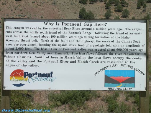
Why is Portneuf Gap Here?
This canyon was cut by the ancestral Bear River around a million years ago. The canyon
cuts across the north-south trend of the Bannock Range, following the trend of an east-
west fault that formed about 100 million years ago during formation of the Idaho-
Wyoming thrust belt. North of the fault and the highway, the rocks of the Chinks Peak
area are overturned, forming the upside-down limb of a geologic fold with an amplitude of
about 2,000 feet. The basalt flow of Portneuf Valley was erupted about 600,000 years ago
from northern Gem Valley near Bancroft. Two lava flows followed the river canyon for
about 40 miles. South of here in Marsh Valley the lava flows occupy the center
of the valley and the Portneuf River and Marsh Creek are restricted to the
edges of the valley.