Entry Points:

About Bear Lake Valley
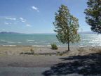
Bear Lake Valley lies high in the Wasatch Mountains on the Utah-Idaho border. It is named for the beautiful Bear Lake which lies at the south end of the valley. The valley is about thirty miles long and about five miles wide. The lake's normal water level is 5,923 feet, and the valley is mostly pretty close to 6,000 feet in elevation.
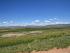
The Bear River Mountain Range border the valley on the west, with peaks that reach above 9,000 feet in elevation, covered in evergreen and aspen forests. On the east side a range of lower mountains stand which locally are called the East Hills. The flat tops of these hills are called the Bear Lake Plateau. Their elevation maxes out around 7,000 feet, and they are mostly covered in sagebrush with a few stands of quakies, and are somewhat arid looking. At the south end of Bear Lake Valley, the East Hills converge with the Bear River Mountains. At the north end the valley a scattering of hills narrow the valley down to where the Bear River can just fit through.
On the Utah side of the border, Bear Lake Valley is mostly filled up with the lake. On the Idaho side, it includes a large area of farmland and swamps. This subdivision of the UntraveledRoad tour includes just the Idaho portion of the valley.
The Bear River enters Bear Lake Valley through a gap in the East Hills, near the north end of the valley. In the early 1900s the Rainbow Canal was built to divert the river into Bear Lake and the Bear Lake Outlet canal was built to carry water back to the Bear River. A levee was built along the north end of the lake with a spillway and power plant. Numerous creeks flow out of the Bear River Mountains and a few from the other side of the valley.
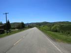
U.S. Highway 89 heads northward along the west side of the valley and then turns eastward to cross the valley and ascend Montpelier Canyon. Fish Haven, St. Charles, Bloomington, Paris, Ovid and Montpelier all lie on Highway 89. U.S. Highway 30 enters Bear Lake Valley from the east with the Bear River, and then heads north, sort of following the Bear River. Montpelier, Bennington and Georgetown are on its route. A road runs south from Montpelier along the east side of the valley, which is called Dingle Road until it reaches Dingle, the Merkley Road until it reaches the lake, then it is called Eastshore Road. A road crosses the valley on the dike north of the lake, named North Beach Road. State Highway 36 leaves the valley at the northwest corner, ascending Emigration Canyon.