Entry Points:


About Blaine County
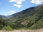
Blaine County includes 2,661 square miles on the north side of the Snake River Basin, reaching into the Sawtooth Mountains. It is home to the elite Sun Valley Resort, a ski resort and all-season resort which has become home to many celebrities and a popular tourist destination. Beautiful forested mountains with many streams cover the northern part of the county.
Blaine County was organized on March 5, 1895 and named after James G. Blain, an Idaho congressman. It had previously been part of Alturas County and went through several reorganizations, the last of which was on February 8, 1919, when Camas County was taken out of it.
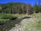
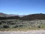
The Wood River flows through Blaine County, from its sources in the Sawtooth Mountains, heading southward through the county's population center around Sun Valley and out into the Snake River Basin. The Wood River Valley is home to the county seat of Hailey, and Ketchum, Bellevue and Sun Valley. A long arm of the county extends to the southeast through the Snake River Basin and all the way down to the Snake River. This area is covered with ancient lava flows and is almost uninhabited. Much of it is included in Craters of the Moon National Monument. The agricultural town of Carey lies at the base of the mountains at the northern edge of this area.
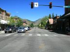
Mining was the original draw to the Wood River Valley, but today the main focus is tourism. The streets of Ketchum are lined with shops catering to tourists and are crowded with people on foot and in cars, checking out the town's sights. Sun Valley has become a place of scenic beauty with immaculately tended landscaping and architectural beauty and an inviting openness and harmony with nature.
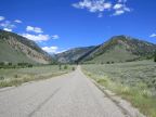
State Highway 75, known as Sawtooth Scenic Byway, passes up through the Wood River Valley. U.S. Highway 20 intersects it, traveling along the base of the mountain parallel to the south boundary of the county. U.S. Highways 26 and 93 cross the southeast arm of the county as a combined route, skirting the Craters of the Moon area. The lowest elevation is 4,620 in the Snake River Basin. The highest point is 12,009 feet at Hyndman Peak, near Trail Creek Road on the boundary with Custer County. The population, as of 2000, is 18,991.
For More Information:
See Blaine County's official site and Wikipedia's Blaine County article.