Entry Points:

About Butte City
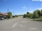
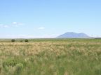
Butte City sits in the Snake River Plain near the southern tip of the Lost River Mountain Range. The deserts stretch to the horizon to the south, with the exception of the Big Southern Butte, a solitary peak which rises from the the desert prominently to the southeast of town, and for which the town is named. To the north, there are a couple miles of farmland before the first foothills of the mountains begin. The Big Lost River flows past Butte City a few miles to the south, where it eventually gets “lost” in the lava beds of the desert.
With a population of just 76 persons, Butte City is a tiny ranching town. It is also close to the Idaho National Laboratory (INL) where atomic power was developed in the mid 1900s.
U.S. Highway 20 & 26, a combined route, heads east and west from Butte City, leading to Arco on the west and the INL site to the east. No other roads leave immediately from Butte City, although a few primitive roads nearby lead into surrounding country.
For More Information:
See Wikipedia’s Butte City, Idaho article.
Street Index
|
Birch Street Cedar Street Eighth Street |
Ninth Street Seventh Street U.S. Highway 20 & 26 |