Entry Points:

About Canyon County
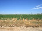
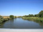
Canyon County is a small county just west of Boise which includes suburbs of the Boise metropolitan area. The county also includes some of Idaho's most productive farmland in the grasslands surrounding the Snake and Boise Rivers. The Snake River forms the county's southwest and the Boise River flows westward through the center of the county, eventually joining the Snake River. The state of Oregon borders the county along a short section at the western tip.
The famous Fort Boise of the Oregon Trail was built in 1834 near Parma in Canyon County. Built by the Hudson's Bay Company to support their trapping operations for beaver skins, it became a major stop on the Oregon Trail, which also passed through Canyon County. At first glance, it’s name would appear to be a misnomer since the terrain is predominantly flat. But the Boise River passes through Canyon Hill near Caldwell in a small canyon which is the namesake of the county.
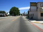
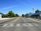
Interstate 80 is the major highway through the county, connecting Nampa and Caldwell with Boise to the east. In the other direction, it turns northwest at Nampa and crosses into Oregon. U.S. Highways 20 and 26 also cross Canyon County, (a combined route) heading east to west, and U.S. Highway 95 passes through the western tip of the county.
Canyon County was organized on March 7, 1891 with the county seat at Caldwell. It covers 604 square miles. The population was 188,923 at the 2010 census. The elevation ranges from 2170 feet on the Snake River to just 3,084 feet at Pickles Butte in the south part of the county.
For More Information:
See Canyon County’s official site at, www.canyoncounty.org.
See also Wikipedia, Canyon County, Idaho.