Entry Points:

About Chesterfield
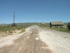
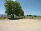
Chesterfield sits on a grassy hill overlooking the north end of Portneuf Valley. Behind it the Chesterfield Mountains rise gradually in grass-covered slopes that obscure the higher peaks behind. An old church, a school, an old store, along with a number of cabins and a couple houses remain of the one-time pioneer settlement that flourished here. Today ranchers still work the ground, and a few farmhouse lie scattered on the periphery of the town, but Chesterfield itself remains as a museum-piece of the early west. A grid of streets, laid out in a neat pattern aligned with north, marks out the original townsite.
Mormon settlers arrived in Chesterfield around 1879. The Oregon Trail passed through the town, and the settlers helped travelers who at this point were "tired, discouraged and ill." The town grew to some 400 people, but eventually the changing world brought about its abandonment. The Oregon Trail fell into disuse, the railroad and main roads passed far to the south. Today the townsite and its structures are protected as a historic site.
Street Index
|
a dirt road a road Cemetery Road |
Chesterfield Road Loveland Lane Twenty-Four Mile Road |