Entry Points:

About Holbrook
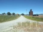
The tiny ranching town of Holbrook lies in the remote Curlew Valley in the arid and sparsely populated grassland north of Great Salt Lake. The valley stretches for many miles to the south and northeast, and is rimmed by hilly mountains on the east and west. Because the nearby mountains do not reach as high as many ranges of the Rocky Mountains, this area receives a modest amount of rainfall. Despite this, with the help of irrigation water, grassland and ranchland fills the valley.
Deep Creek flows past Holbrook, coming from its sources in the Deep Creek Mountains northward, and flowing southward towards Great Salt Lake. It is a small creek and may be dry at seasons.
The city consists of a grid of streets, with four streets going east and west, and about as many to the north and south. Only a scattering of houses are found through the town, along with other farm buildings. Only the main street is paved. The main feature of the town is the city park and the old Mormon meetinghouse located on the same block. Stone Road passes the town on the west heading south towards Snowville, and Idaho Highway 38 passes by on the north, heading east to Malad. The elevation os 4,779 feet.
Street Index
|
Center Street First East Street First North Street |
First South Street First West Street Main Street |
Second East Street Second North Street Stone Road |