Entry Points:

About Marsing
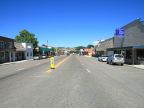
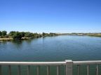
Marsing is an agricultural community built on the banks of the Snake River. In 2000 the population was 890 people. The town originated as the terminus of a railroad line, but the trains stopped running many years ago and the tracks have been removed with little trace remaining. Now Marsing is served by two state highways. Idaho Highway 55 passes through the town on Main Street, crossing the Snake River on a large bridge. Idaho Highway 78 heads south from the west side of town and follows the river for a long distance. U.S. Highway 95 just misses Marsing a couple miles to the west.
A wide, irrigated grassland surrounds Marsing where vast amounts of food are produced each year. Across the river the land rises gradually. Projecting from this slope is a pinnacle of black lava rock named Lizard Butte, a landmark that can be seen for miles around. It is the tip of a vast lava flow that covers much of southern Idaho in the Snake River Plain.
Marsing lies along an alternate route of the Oregon Trail. In 1888 George Froman built a ferry to transport pioneers across the Snake River here.
The elevation at Marsing is 2,260 feet.
For More Information:
See the Wikipedia article on Marsing.