Entry Points:

About Bliss
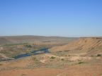
The town of Bliss is perched above the Snake River Gorge at the edge of the deserts and lava fields of the Snake River Plain. The 500-foot drop to the river from the edge of town provides a stunning view from points along the town's main street. The Snake River approaches from the south and makes a wide bend near Bliss and then flows westward. In spite of the nearby freeway, Bliss enjoys an isolation from the busy modern world and a quietness in the open spaces surrounding it.
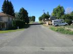
Bliss was founded in 1881 by David Bliss, and was a stop on the newly built Oregon Short Line. Typical of railroad towns, the streets of Bliss are narrow and laid out in a grid originating from the train tracks. Previous to the railroad, the Kelton Road used to pass near Bliss and was the major route for freight and travel through the area.
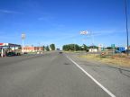
The population of Bliss is 275, as of 2000. Three major highway routes meet at Bliss. Interstate 84 passes by the town on the northeast, U.S. Highway 30 passes through the town and heads south, descending into the the Snake River Gorge and coming to Hagerman. U.S. Highway 26 leaves the freeway at Bliss and heads eastward towards Gooding. The elevation at Bliss is 3,262 feet. Irrigated fields cover parts of the desert to the north and east and grasslands and sagebrush cover the rest