Entry Points:

About St. Charles Canyon
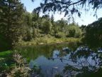
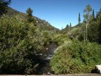
Near the north end of Bear Lake lies the community of St. Charles, and the canyon opening into the mountains to the west is named St. Charles Canyon. It makes a gradual climb for several miles westward and then divides into three forks. A creek, named St. Charles Creek, flows from the canyon into Bear Lake.
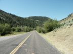
Minnetonka Cave, operated by the forest service with daily guided tours, is on the southern slope of the canyon. A paved road comes up the canyon to where it forks out, and then loops back on the mountainside, to the cave. There are several campgrounds in the canyon. Foot trails lead further up into the forks of the canyon.
Patches of evergreen forests cover the mountains, interspersed with sagebrush and quaking aspen. Willows line the creek. The elevation at the mouth of the canyon is 6,000 feet, and the surrounding mountains reach to 8,000 and 9,000 feet. It is a beautiful area for camping and hiking.
Street Index
|
Blue Pond Spring Trail Deer Lane Deer Ridge Trail |
Dry Canyon Road Middle Fork Trail Minnetonka Cave Road |
North Fork Road North Fork Trail St. Charles Creek |