Entry Points:

About Rockford
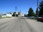
The farming town of Rockford is surrounded by the farmland of the Snake River Plain a few miles west of the Snake River. A large General Mills Plant occupies one side of the highway, and the second largest operation in town is a farmer’s supply store. A railroad runs between the highway and the General Mills Plant, and a few meandering streets lie on the other side of the highway. The population was 276 at the 2010 census.
The Snake River Plain stretches to the horizon to the west, where a no-man’s land of volcanic lava fields covers the whole countryside. Mountains can be seen in the distance in the other directions. A network of canals crisscrosses the farmland without which the land would be a barren desert, as it was a hundred years ago.
Idaho Highway 39 is the highway that passes through Rockford, heading nearly northeast-southwest. Southward it reaches other small farming towns such as Pingree and Springfield. To the north it comes to Riverside and Blackfoot. An extensive network of rural roads branches out through the area. The elevation is 4463 feet.
Street Index
|
Broadhead Lane Hilltop Road Rockford Road Scott Road |
State Highway 39 Vel Jean Boulevard Vel Jean Street |