Entry Points:

About Elba Basin
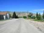
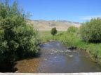
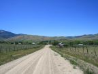
Elba Basin is a small valley nestled between the Albion Mountains and the Jim Sage Mountains in southern Idaho. Two beautiful mountain peaks, Cache Peak and Mount Harrison overlook the valley. Mount Harrison is 9,265 feet tall and Cache Peak is 10,339. The town of Elba sits at 5,160 feet. Ranches and farmland fill the valley, sagebrush covers the lower slopes and evergreens and quaking aspens cover the upper slopes. City of Rocks National Reserve is located a short drive to the southwest.
Elba is not an incorporated town, however it sports a beautiful, historic stone church building and an old brick school (which is no longer in use). Across the street from the church is a red brick building which bears the inscription "ELBA RELIEF SOCIETY 1901," an unusual remnant from the days when the Mormon church built separate buildings its women's organization, named the Relief Society. Atop its roof is mounted a bell which would have been used signaling the community for meeting, as well as messages (in the days before telephone).
The town of Elba does not occupy one spot in the valley, but houses are scattered around on a few roads that criss-cross the valley. No population figure is available for Elba, and no historic markers were found. It was clearly settled by Mormon pioneers in the late 1800s, and visually is probably not much different than it was a hundred years ago.
Street Index
|
1125 East Road 1200 East Road 1950 South Road 2000 South Road |
Anderson Lane Cassia Creek Durfee Road Elba-Almo Road |
Oakley - Elba Road Ottley Road |