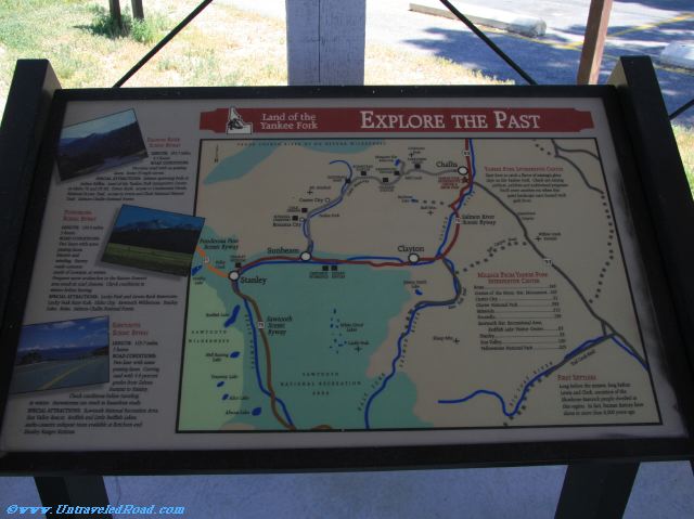
Explore the Past
Salmon River Scenic Byway
LENGTH: 262.7 miles, 3.5 hours
ROAD CONDITIONS:
Two-lane road with no passing
lanes. Some 35 mph curves.
SPECIAL ATTRACTIONS: Salmon spawning beds at
Indian Riffles; Land of the Yankee Fork Interpretive Center
at Idaho 75 and US 93; Tower Rock; access to Continental Divide
National Scenic Trail; access to Lewis and Clark National Historic
Trail; Salmon-Challis National Forest.
Ponderosa Scenic Byway
LENGTH: 130.9 miles, 9 hours.
ROAD CONDITIONS:
Two-lane with some
passing lnaes.
Narrow and
winding. Snowy
roads common
north of Lowman in winter.
Frequent snow avalanches in the Banner Summit
area result in road closures. Check conditions in
winter before leaving.
SPECIAL ATTRACTIONS: Luck Peak and Arrow Rock Reservoirs;
Lucky Peak State Park; Idaho City; Sawtooth Wilderness; Stanley
Lake; Boise; Salmon-Challis National Forest.
Sawtooth Scenic Byway
LENGTH: 115.7 miles, 3 hours
ROAD CONDITIONS:
Two-lane with some
passing lanes. Curving
road with 5-6 percent
grades from Galena
Summit to Stanley.
Check conditions before traveling
in winter. Snowstorms can result in hazardous roads.
SPECIAL ATTRACTIONS: Sawtooth National Recreation Area;
Sun Valley Resort; Redfish and Little Redfish Lakes;
audio-cassette milepost tours available at Ketchum and
Stanley Ranger Stations.
Yankee Fork Interpretive Center
Start here to catch a flavor of mining’s glory
days on the Yankee Fork. Check out mining
artifacts, exhibits and audiovisual program.s
You’ll enter another era when this
quiet landscape once buzzed with
gold fever.
First Settlers
Long before the miners, long before
Lewis and Clark, ancestors of the
Shoshone-Bannock people dwelled in
this region. In fact, human history here
dates to more than 8,000 years ago.
Don't miss the rest of our virtual tour of Custer County in 3748 images.