Entry Points:

About Fish Haven
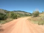
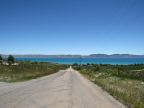
Fish Haven lies between the shore of Bear Lake and the Bear River range of mountains, occupying a narrow strip of the valley and extending into the foothills. Fish Haven Canyon cuts westward into the mountains, through which flows a small stream, Fish Haven Creek. The mountains boast beautiful alpine forests and meadows, while the lower slopes closer to town are covered in sagebrush. The beautiful lake, known for it's blue water, extends for ten miles east of Fish Haven.
Fish Haven was settled in 1864 by Mormon pioneers, including Hugh Findlay and Henry Howell. Originally settled as a farming community, it is becoming a resort and retirement community with homes being built on the hills overlooking the lake.
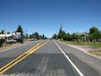
U.S. Highway 89 passes north-south through Fish Haven, leading to St Charles to the north, and Garden City to the south. The town began where Fish Haven Canyon road intersects the highway, and no other streets were originally laid out. As development has moved into the hills, roads have been built in an irregular fashion, in the style of a mountainside retreat. The Utah border is just a few miles to the south. The elevation is 5,951 feet above sea level on Main Street. An unnamed mountain peak just a few miles east of Fish Haven is 9,217 feet high.