Entry Points:

About Fish Haven Canyon
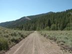
Fish Haven Canyon was cut into the slopes of the Bear River Mountain Range by Fish Haven Creek. It gets its name from the town of Fish Haven, which lies at the mouth of the canyon, and on the shore of Bear Lake. Fish Haven Canyon is about six miles long, just the short distance from the top of the ridge to the shore of the lake. After passing through the narrow lower portion of the canyon, several tributaries break off, including the Left and Right Forks, and Saducee Hollow. The elevation at the top is about 7,900 feet, and the elevation at the lake is 5,923 feet.
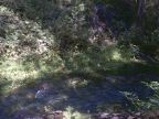
Sadducee Spring is one of the points of interest in the canyon. It flows into a secluded dell off to the side of the canyon, and supplies most of the water to Fish Haven Creek. Forests of quaking aspen and evergreen trees cover the southern canyon wall, while sagebrush and small plants grow on the north side slope.
Fish Haven Canyon Road climbs the canyon from U.S. Highway 89 in Fish Haven all the way to the top, where it meets Green Canyon Road. Beyond Sadducee Spring the road is very rough, suitable for 4 wheel drive. A number of side roads break off the main road. Most of the canyon is in Cache National Forest
Street Index
|
Canyon Estates Drive Fish Haven Canyon Road Fish Haven Creek |
Left Fork Road Sadducee Hollow Road Sadducee Spring Trail |