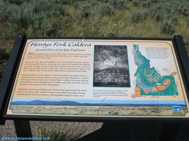
Henrys Fork Caldera
Ground Zero of an Epic Explosion
You are standing at the site of of one of the largest volcanic explosions in geologic
history. The explosion of Yellowstone Super Volcano, 1.2 million years ago,
created the Henrys Fork Caldera.
Look to your left. The curving ridgeline you see to the southwest forms a portion
of the Henrys Fork Caldera-the remains of a volcano that exploded and collapsed
into itself. The blast ejected 67 cubic miles of molten rock into the sky-Mount St.
Helens, during 1980, ejected 1/4 cubic mile. The blast buried Eastern Idaho in ash
up to 1,000 feet thick-briefly obliterating all life for hundreds of square miles.
Geologists believe that the caldera is a result of the Yellowstone Super Volcano—a
deep thermal mantle plume of molten rock presently below Yellowstone. Evidence
of the super volcano's track across Southern Idaho is visible as volcanism, faulting,
and uplift that resulted during the past 16 million years when the North American
Continental Plate passed over the mantle plume.
Earthquake activity beneath Yellowstone National Park indicates that mantle
plume is still active today. Another eruption of the Yellowstone Super Volcano
would plunge the Earth into darkness-altering global climate for many years.
[Picture Captions]
The May 18, 1980 eruption of Mt. St.
Helens in Washington State ejected nearly 1/4
cubic mile of rock and as into the air.
The Yellowstone Super Volcano which
created the Henrys Fork Caldera was 250
times more powerful than Mr. St. Helens.
This is the west rim of the Henrys Fork Caldera. It marks
the remains of a volcano that violently exploded and
collapsed. The Henrys Fork Caldera is one of the largest
most symmetrical in the world measuring nearly 23 miles
in diameter.
Geologists believe that the Yellowstone
Super Volcano is stationary and that the
North American Continental Plate is
moving. As the Continental Plate
moves southwest at about 1 inch per
year, the volcano appears to move in a
northeast track. Evidence of the
volcano's track is visible as a string of
volcanic fields that span the entire
length of the Snake River Plain.