Entry Points:

About Malta
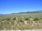
The tiny town of Malta is the largest in the Raft River Valley, a broad and arid valley in Idaho near the Utah border. Malta lies on the western side of the valley, with the Cotterel Mountains a few miles off to the northwest and the Jim Sage Mountains to the southwest. The Raft River flows past a couple miles to the east and Cassia Creek passes through the town, although it is dry much of the time. Irrigation water provides for farmland in patches around the valley, but much of it is dry and even sagebrush is sparse in places. The scenery is beautiful however, with tall mountains rimming the valley, including especially the Albion Mountains, whose 10,000-foot peaks are visible to the west over the closer, shorter mountains.
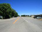
Malta lies at 4,525 feet in elevation and has a population of 193, according to the 2010 census. State Highways 77 and 81 both end at Malta; route 77 heads west into the Albion Mountains, while route 81 heads north. Both connect up to towns in the Snake River Basin. Interstate 84 passes by Malta eight miles east in the Raft River Valley. There used to be a U.S. Highway 30 South route, which passed through Malta, taking the route of today's Idaho highway 81 from Burley to Malta, and then continuing southwest into Utah. This route was decommissioned when Interstate 84 was built, but the road is still in use.
For More Information:
See the Wikipedia article on Malta, Idaho.