Entry Points:

About Ovid
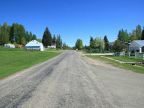
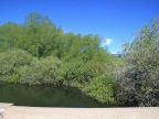
The town of Ovid is nestled against the hills at the edge of Bear Lake Valley, surrounded by grasslands. A ridge of hills reaches down from the north right to Ovid, and Bear Lake Valley divides, with a smaller arm stretching to the northwest. The Bear River passes by a couple miles to the east, and Ovid Creek flows from the northwest to meet it. Forested mountains line the valley on both sides, and are most visible to the southwest from Ovid. The valley extends to the horizon to the south, and at the far end is the beautiful Bear Lake.
Ovid was settled in 1864 by Mormon pioneers, as a coordinated effort to settle all this area. Ovid was never incorporated, and its population is quite small, perhaps a hundred. The name is pronounced Oh-vid. Ranching is the traditional activity for the area, and there is a lumbermill in Ovid.
U.S. Highway 89 passes through Ovid, making a turn in the town. It heads south to Paris, and northeast to Montpelier. Idaho Highway 36 begins at the bend and heads west across the Bear River Mountains into Cache Valley. The elevation is from 5,930 to 5,980 feet.
For More Information:
See the brief Wikipedia article on Ovid, Idaho.
Street Index
|
Cedar Lane Cemetery Road Center Road Johnson Road Long Hill Road |
North Road Ovid Creek Ovid Road South Road State Highway 36 |
State highway 36 U.S. Highway 89 Willow Bend Street |