Entry Points:

About Bonneville County
Bonneville County occupies a small but populous farmland and urban area along the Snake River, and a large area of hills and mountains east of there, much of which is nearly uninhabited. The Snake River, the largest river in Idaho, passes along the north side of the county, leaves it to the north, and then comes back to flow southward along its western boundary. Idaho Falls, Bonneville County's major city, was settled on the Snake River; and is named after a waterfall on the river. Bonneville County is the fourth most populous in Idaho.
Bonneville County was established in 1911, being split off from Bingham County, which lies to the south. It is named after Benjamin Bonneville (1796-1878), a French-born explorer who explored this area in the 1830s. THe county covers 1,900 square miles and has a population of 104,234 (as of the year 2010). The lowest elevation is about 4,600 feet where the Snake River leaves the county. The highest point is 10,025 feet at Mount Baird, located near the county's northeast corner.
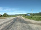
The western end of Bonneville County lies in the Snake River Basin. This basin covers much of southern Idaho and made an easy route for exploration and early settlers. The Snake River provided irrigation water, and many settlements sprung up in this area, one of which was Idaho Falls. The Snake River, which originates in Yellowstone National Park, passes through the Palisades Reservoir and a narrow valley in the east part of the county, before emerging into the Snake River Basin. Southwest of the Snake River lies the Caribou Mountain Range, and on the northeast lies the Snake River Range. Grays Lake Valley lies on the southern boundary. The tip of the county west of Idaho Falls is covered with lava fields.
Interstate 15 is the main route of travel through the county, going north and south along the Snake River. It passes through Idaho Falls connecting north into Montana and south to Blackfoot and Pocatello. U.S. Highway 26 follows the Snake River all the way through the county. U.S. Highway 20 dips southward into the county to hit Idaho Falls, and then heads into the west deserts and lava fields. U.S. Highway 91 begins at Idaho Falls and parallels the freeway southward. A historic alignment of U.S. Highway 191 also passes through the county.
For More Information:
See Bonneville County's official site at www.co.bonneville.id.us and the Wikipedia article on Bonneville County.