Entry Points:

About Mackay
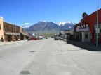
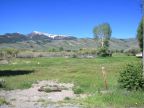
The town of Mackay sits in the Big Lost River Valley, near the Big Lost River, surrounded by towering mountain peaks. Mount McCaleb, straight north of Mackay, is 11,682 feet high. Invisible Mountain, in spite of its name, can't be missed, rising to 11,830 feet, above the streets to the northeast of town. To the west, White Knob reaches 10,529 feet. With Mackay at 5,900 feet, these mountains rise another 6,000 feet above the town, dominating the horizon with their majestic slopes. The peaks are above the tree line, where their only covering is snow. Forests cover the middle levels, and sagebrush provides the color of the lowest slopes.
Mackay was a mining town and millions of dollars worth of gold, silver, copper and other metals were extracted from the surrounding mountains, known as the Alder Mining District. The mines are all closed down now, and a self-guided tour of “Mackay’s Mine Hill” is available to visitors. Ranching in the fertile, well-watered Lost River Valley, along with tourism, keeps Mackay alive today. The Mackay Reservoir, a few miles to the northwest, provide a venue for watersports, and the mountains are a paradise for camping, hiking, hunting, fishing, and sight-seeing. Mackay’s population was 566 at the 2000 census. The name is pronounced Mack-ee.
Mackay was incorporated on October 14, 1901, and the railroad reached Mackay soon afterward. The White Knob Mine was for a while the largest producer of copper in Idaho, and Mackay was sometimes referred to as “Copper City”. During the years of prohibition, Mackay became well-known as a source of “moonshine.” In 1983 Mackay suffered a severe earthquake, centered at Mt. Borah, twenty miles to the north, which destroyed numerous older buildings.
U.S. Highway 93 passes through Mackay, following the Lost River Valley. The Valley runs northwest-southeast, forcing the highway, which is a north-south route, to angle in that direction, and also resulting in the grid of streets being laid out on a diagonal. Highway 93 continues northwest into the Thousand Springs Valley and on to Challis. To the southeast it leads to Moore and Arco.
Mackay is a quiet town of ranchers and other simple folk who are happy to leave the big commercial tourism industry to Sun Valley, a major resort town on the other side of the mountains to the west.
For More Information:
See Mackay’s official site at mackayidaho.com, and Wikipedia’s Mackay, Idaho article.